Interim Report Section 3: Inquiry Issues and Recommendations
This part of the Interim Report discusses some of the principal issues that the Royal Commission must consider under the Terms of Reference. It sets out some conclusions that have already been reached and some possible conclusions on the basis of the information that has been gathered to date. There are some definite recommendations for change, and other recommendations for further processes, whether in subsequent stages of the Royal Commission’s Inquiry or in other forums.
There are few definite recommendations on substantive matters because the Inquiry is only part-way through, the peer reviews of advice to the Royal Commission have not all been received, the evidence and submissions of interested parties have yet to be received and no hearings have been held. The Royal Commission is mindful of the limitations, which therefore apply to stating conclusions at this point, and considers it inappropriate, for example, to make any findings about the reasons for the failure of the CTV and PGC buildings, or the implications of those failures. Possible implications for existing building controls arising out of the study of the representative sample of buildings would also generally be premature at this point, with a few exceptions. In the case of the failure of URM buildings, enough is presently known for some clear recommendations to be made. Safety considerations have also led us to make other recommendations. On the basis of reports that we have received from structural engineers familiar with the effects of the earthquakes on buildings in the CBD, there appears to be a clear need to reconsider some practices associated with the construction of stairs, floors, structural concrete members and structural walls.
The Royal Commission is conscious of the need to produce an Interim Report that responds appropriately to the obligation in the Terms of Reference to make interim recommendations that will “inform early decision-making on rebuilding and repair work that forms part of the recovery from the Canterbury earthquakes”. The Royal Commission considers that this obligation cannot properly be fulfilled by deferring every issue to the Final Report, and has stated some conclusions and made some recommendations for change accordingly. If persuaded at a later stage of the Inquiry that any of these conclusions and recommendations need to be reconsidered, the Royal Commission will do so.
The recommendations are discussed later in this section of the report, and highlighted in the preceding Section 1.
3.1 Seismicity
The advice that the Royal Commission has received from GNS describes the forces that give rise to earthquakes in New Zealand generally, and Canterbury and Christchurch in particular2:
“New Zealand straddles the boundary zone between the Australian and Pacific tectonic plates, which are moving relative to each other at 35-45 mm/yr. In the North Island, the plates are converging and the relatively thin ocean crust of the Pacific Plate dives down westward beneath the eastern North Island just offshore of the east coast. Similarly offshore of Fiordland the thin ocean crust of the Australian Plate is diving eastward beneath Fiordland.
“In the central and northern South Island, however, the crust of both the Pacific and Australian plates is very thick, so one cannot be driven beneath the other. Here the plates collide, with 75% of the motion between the plates being built up and then released during major earthquakes along the Alpine Fault. To the east of the Alpine Fault, the remaining 25% of the plate motion occurs through occasional earthquakes on a complex web of active faults. This motion extends all the way to the east coast, where faults such as those beneath the Canterbury Plains accommodate 1-2 mm/yr of the overall plate motion. It is inevitable that this steady build-up of deformation across the Canterbury Plains will occasionally be released as earthquakes.
“Because it straddles a major plate boundary, New Zealand has a long history of earthquakes ranging from tiny tremors detectable only by sensitive instruments to violent earthquakes causing major damage and many fatalities. The more powerful earthquakes have occurred at irregular intervals, separated by relatively quiescent periods. Since European settlement of the Canterbury Plains began in 1853, Christchurch has experienced intermittent damage from earthquake shaking on about 10 occasions.
However, before the earthquakes in 2010 and 2011, few of these damaging earthquakes were local – more frequently, damage was caused by shaking from large earthquakes on more distant faults”.
The GNS report notes that the Canterbury earthquake sequence has included a mixture of sideways (strike-slip) and vertical (reverse) faulting at shallow depths on previously unidentified faults at varying distances from the Christchurch CBD. The three largest events (4 September 2010, 22 February 2011 and 13 June 2011) released levels of energy that were high for the size of the fault.
These faults initially were formed millions of years ago by tectonic movements inducing tension in the base rock, so that they are steeply inclined to the horizontal. Subsequently the tectonic movements changed to induce compression across the faults. The faults seldom fail so that the return period for earthquakes is long and hence there is little disruption of rock adjacent to the fault plane. A consequence of this is that high compression (stress) is sustained in the rock before the slip occurs and when failure does take place there is a high stress drop (strain energy release). The GNS report expresses the opinion that focussing of the seismic shaking, arising from the direction of the fault (‘directivity’) increased the severity of the ground motions experienced in the CBD during the 4 September and 22 February earthquakes, but was not significant for those of 26 December and 13 June.
A description of the earthquakes is set out in the following table:
Table 2: Earthquake Sequence: Characteristics
| Date/Epicentre | Time |
Magnitude3 | Intense Shaking Duration | Major Effects |
|---|---|---|---|---|
| Date: 4 September 2010 Epicentre: 40km west of Christchurch |
4:35am | 7.1 | 8–15 seconds |
|
| Date: Boxing Day earthquakes – 26 December 2010 Epicentre: 1.8km NW from Christchurch Cathedral |
10:30am | 4.7 | 1–1.7 seconds |
|
| Date: 22 February 2011 Epicentre: 6km southeast of Christchurch CBD |
12:51pm | 6.2 | 8–10 seconds |
|
| Date: 13 June 2011 Epicentre: near Sumner |
14:20pm | 6.0 | 6–7.5 seconds |
|
The GNS report observes that there was a close match between the extent of damage caused by the earthquakes and the degree of horizontal ground shaking. However, some structural engineers involved in reviewing damage to buildings in the Christchurch CBD consider that the high magnitudes of vertical ground motion may have contributed significantly to the observed damage. The Royal Commission will want to give further consideration to this issue before providing its Final Report.
The GNS Science report refers to measurements recording peak accelerations at sites close to the Christchurch CBD, which were approximately twice as strong during the 22 February earthquake as during the other three most significant earthquakes. The ground motions on 22 February were extremely high, reaching 1.7g in the horizontal direction and 2.2g in the vertical direction in Heathcote Valley near the epicentre, and up to 0.8g vertically and 0.7g horizontally in the CBD. Although the 4 September earthquake was significantly larger than the other three most significant events, its epicentre was over 35 kilometres from the Christchurch CBD with the result that the ground accelerations in central Christchurch were correspondingly reduced. The epicentre of the 22 February earthquake was approximately 6km from the Christchurch CBD.
The following diagrams (Figures 1 and 2), extracted from the GNS report (pages 18 and 23), illustrate the maximum horizontal and vertical ground accelerations for the 4 September and 22 February events:
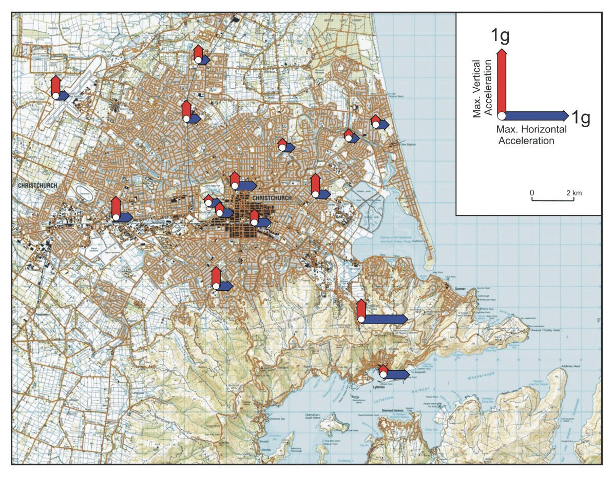
Figure 1: Maximum horizontal and vertical PGAs recorded during the 4 September 2010 earthquake at GeoNet stations
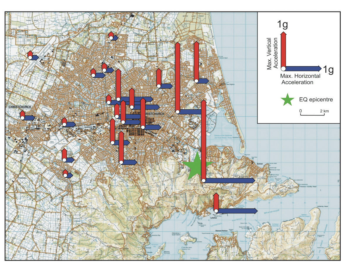
Figure 2: Maximum horizontal and vertical PGAs recorded during the 22 February 2011 earthquake at GeoNet stations
GNS reports that at certain recording sites in the Christchurch CBD shaking from the three largest events exceeded the most stringent of the design levels used in NZS 1170.5 for certain frequencies of shaking.
The GNS report states that “the level of seismic hazard in Canterbury is currently higher than normal because of the numerous aftershocks that are occurring. In addition there is a slight possibility that an earthquake of a size comparable to the main shock might be triggered”. The report observes that the elevated level of hazard must be considered when reassessing the safety of existing structures and when designing new buildings and infrastructure.
As a consequence, GNS is developing a new seismic model for Canterbury that is intended to reflect the increased level of hazard. One consequence of this work has been to increase the seismic hazard factor (‘Z’) for Christchurch. This factor is used to assess the magnitude of design level earthquakes and it varies from location to location in New Zealand according to the assessed risk from earthquakes. Previously, the hazard factor for Christchurch was 0.22. It has now been increased to 0.3, an approximate 35% increase. The corresponding value of Z in Wellington is 0.4, in Hamilton 0.16, Gisborne 0.36, Napier 0.38, Hastings 0.39, and in Auckland and Dunedin 0.13.
There are additional changes in other factors related to seismic design discussed below.
The cost involved would make it impractical to identify all active faults in a region, essentially because small faults associated with earthquakes that are magnitude 6, or less, frequently do not leave a visible trace on the ground surface. It is for this reason that, in evaluating the level of earthquake risk, the National Seismic Hazard Model (the model) currently assumes that an earthquake of up to magnitude 7.2 could occur on an unknown fault virtually anywhere in New Zealand, although in locations of low seismicity the likelihood of such an occurrence is very low. For the purposes of assessing the likely ground motion, it is assumed the fault is located at a distance of 20km from the point of interest as it is (statistically) unlikely that the point of interest will be very close to the fault. GNS refers to the need to ensure that the model correctly accounts for the shaking that can be anticipated from such earthquakes.
GNS also observes that while directivity effects are accounted for in the model for some major active faults, consideration will need to be given to including directivity for smaller earthquakes. The extreme vertical accelerations that were generated by the 22 February earthquake require re-evaluation of the approach to designing for vertical motions that currently applies under NZS 1170.5.
For the Christchurch metropolitan area there is a significant risk of earthquakes associated with ruptures of distant faults such as the 650km long Alpine Fault and Porters Pass – Grey Fault. An Alpine Fault earthquake will not be a ‘high stress drop’ such as the February earthquake. Due to the distance to the Alpine Fault the predicted peak ground accelerations are anticipated to be much lower than those experienced in both the September and February earthquakes. However, the shaking will have a much longer duration, as illustrated in Figure 3, which compares the observed ground accelerations in time with the corresponding values predicted for an earthquake on the Alpine Fault.
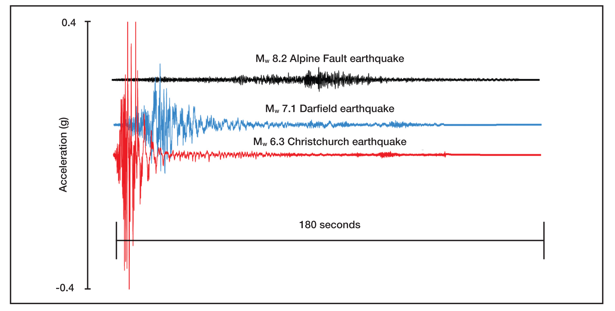
Figure 3: Three minutes of synthetic acceleration time histories for the larger of the two horizontal components, in terms of PGA, for a potential Alpine Fault event (black) compared with the accelerations from the Mw 7.1 Darfield earthquake (blue) and the 22 February Mw 6.3 Christchurch earthquake (red) as recorded at the Christchurch Botanic Gardens GeoNet station (CBGS)
As noted above, a number of changes have been made to the design level earthquakes for Christchurch as a result of seismic modelling carried out by GNS. This resulted in the increase of the seismic hazard factor, Z, from 0.22 to 0.3. The Royal Commission notes that the return factor, R, used for assessing the level of earthquake actions for the serviceability limit state has also been increased from 0.25 to 0.33 to allow for the increased seismicity associated with aftershocks. (An explanation of the ‘serviceability’ and ‘ultimate’ limit states is given in Annexure 1 at the end of Section 3). These changes are very significant in that both factors impact on the design level earthquake for the serviceability limit state where, together, they result in an 80 per cent increase in design actions for this limit state compared to the corresponding values in use until May 2011. It should be noted that serviceability is considered for the design of new buildings but is not considered in the retrofit of existing structures.
The epicentre of the 22 February earthquake was located on the outskirts of Christchurch at a distance of approximately 6km from the centre of the CBD. The damage from this earthquake was predominantly located within a distance of 12km of the fault. This observation supports the decision in the GNS model to assess the likely ground motions from a hidden fault for an earthquake located at a distance of 20km. It is unfortunate for Christchurch that:
- this hidden fault was located close to the centre of Christchurch;
- the fault plane was inclined in a direction that directed a high proportion of the strain energy release towards the centre of Christchurch; and
- this fault, which has a very long return period (of the order of 10,000 years), happened to fail in 2011 when a high population density had developed.
Before the Royal Commission can support the adoption of the revised seismic coefficients for the Christchurch region there are a number of aspects that need further investigation:
1. The current seismicity model which is reflected in the New Zealand earthquake actions standard, NZS 1170.5, assumes that the ground motion associated with hidden faults is represented by a magnitude 6.5 earthquake located at a distance of 20km. In the new seismic model this has been replaced by a magnitude 7.2 earthquake at the same distance.
2. Changes were made to the new model for the way in which the design ground motions were derived from observed earthquakes. The Royal Commission understands that the peak ground accelerations for different building periods in NZS 1170.5 were deduced from the most critical of the two horizontal ground motions, which were measured at right angles to each other, suitably modified to allow for terrain, attenuation and other effects. However, it appears from a GNS report4 that in the new seismic model the ground motion has been based on the geometric mean of the observed shaking in the two horizontal directions. This assumption reduces the design seismic ground motions.
3. In the new seismic model a different magnitude weighting factor has been used from that applied for the model in NZS 1170.5.
4. The shape of the design response spectra (which defines how the effective acceleration of a structure in design varies with the period of vibration) is a poor fit with the observed spectra derived from the Canterbury earthquake for the deep alluvial soils in the Christchurch locality. Some revision of the spectral shapes for these soils would appear to be justified.
5. There is some indication from the damage sustained in the Canterbury earthquakes that vertical ground motion may have contributed to the damage. There is a poor correlation between the calculated spectral shapes from the earthquakes and the specified shape in NZS 1170.5 for actions induced by vertical ground motion. Consequently, the method of defining design actions for vertical ground motion needs to be reviewed.
6. The implications of the points made above should be addressed by structural and geotechnical engineers in addition to seismologists.
The Royal Commission recommends that parties appearing before the Royal Commission with relevant expertise address the issues listed in the preceding paragraphs when presenting evidence and submissions later in the Inquiry. The Royal Commission also wishes to receive further information addressing the effect of the high vertical ground motions in the 22 February 2011 earthquake.
Footnotes
2. Webb T. H., Beaven J., Brackley H., Gerstenberger M., Kaiser A., McSaveney E., Reyners M., Somer-ville P., Van Dissen R., Wallace L., Bannister S., Berryman K., Fry B., Holden C., McVerry G., Pettinga J., Rhoades D., Stirling M., Villamor P., and Zhao J., ‘The Canterbury Earthquake Sequence and Impli-cations for Seismic Design Levels’, GNS Science Report 2011/128, July 2011.
3. The magnitude stated in this table is defined as ‘Moment Magnitude’ (MW) which GNS Science advises is commonly used worldwide to characterise large earthquakes. It is a measure of the final displacement of a fault after an earthquake. MW is a rough proxy for the amount of low-frequency energy radiated by an earthquake. ‘Richter Magnitude’ (ML) is the initial magnitude assigned to an earthquake with routine GeoNet processing. It is derived from measurements of the peak amplitude on seismographs and is thus a preliminary estimate of the amount of energy released by the earthquake. References to magnitude in this report are to the Moment Magnitude.
4. Gerstenberger M. C., Rhoades D. A., Berryman K., McVerry G. H., Stirling M. W., and Webb T. 'Update of the Z-factor for Christchurch considering earthquake clustering following the Darfield earthquake’, GNS Science Report 2011/29, May 2011
Return to Contents | Go to Section 2.5 | Section 3 continues
